


UPFIELD
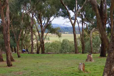
Upfield is a residential and industrial locality 17 km. north of Melbourne, situated in Campbellfield. The name is descriptive of the area's open country. In 1956 the Ford motor car factory was begun on land between the Hume Highway and the railway line from Coburg to Somerton. The State Government announced its intention to construct a railway station (Upfield), and the line was electrified in 1959. South of the Ford factory housing was built and a high school opened in 1968.
UPWEY
Upwey is a residential suburb in hilly surrounds 34 km. east-south-east of Melbourne and 2 km. west of Belgrave. Until the turn of the century Upwey did not have a separate identity. In the middle 1890s the part of the locality was divided into ten-acre blocks as part of the "Scoresby" village settlement scheme, which extended northwards to Ferny Creek. Notwithstanding the "Scoresby appelation, Upwey was known as Mast Gully, after several ship masts had been cut from the gully in 1850. (Mast Gully Creek and Mast Gully Road remain.
In 1897 three sisters, Misses Tullidge, bought a homestead and named it Upwey, after the English village on the River Wey. They persuaded the Victorian Railways to approve a stopping place near their house, and the name Upwey was given to it. The name was adopted by common usage, the Upwey Church of England being built in 1904 (now in the nieghbouring locality of Tecoma).
VERMONT / VERMONT SOUTH
Vermont is a residential suburb 21 km. east of Melbourne, south of Mitcham and the Maroondah Highway and railway line Ringwood. The name seems to have been bestowed either by derivation from Limerick County in Ireland or by the Government Botanist von Mueller who named the surrounding green hills Vermont. The Vermont countryside was well timbered, providing employment for wood cutters in the 1850s. During the late 1850s land allotments of about 50 to 200 ha. were offered to settlers. The first primary school in the district opened in Mt. Pleasant, near the present Uniting Church in Canterbury Road at the border between Forest Hill and Vermont. Seven years later a permanent school site was functioning in Vermont proper, and the single room structure remained in use 100 years later. Vermont was also known as L.L. Vale, after the model farm owned by Dr L.L. Smith, medico and parliamentarian. The name persisted for a while, despite the school site being named Vermont in 1870: the post office was L.L. Vale from its opening in 1881 until 1885. By 1913 Vermont was described as a prosperous fruit-growing district. The area's relative remoteness from land-subdivision activity kept it a mainly rural area with local organisations such as the football club, scouts and a horticultural society (1937).
VIEWBANK
Viewbank is a suburb in Melbourne, Victoria, Australia, 14 km north-east from Melbourne's central business district. Its Local Government Area is the City of Banyule. At the 2006 Census, Viewbank had a population of 6614. The Yarra River and large tracts of Yarra Valley parkland run along one border of the suburb. The Plenty River forms Viewbank's eastern boundary, whilst its northern boundary is defined by Lower Plenty Road (a main road linking Heidelberg and Eltham). Viewbank was named after a farming property (since demolished) built at the junction of the Yarra and Plenty River during the 1840s, and was thus named in response to its outlook. Remnants of Viewbank's farming past can be seen from the historic silos still standing on Banyule Road. The area was primarily developed around the 1960s.
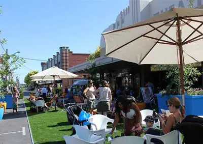
Restaurants, Knox City, Wantirna
WANTIRNA
Wantirna is a residential locality 23 km. east of Melbourne, a few kilometres west of Bayswater. It is neither on a railway line nor on a radiating main road from Melbourne, and consequently underwent residential development later than some of its neighbouring areas. The area attracted settlement as one of the district's earliest cattle runs, Bushy Park, in 1841, which was situated on a track from Melbourne to the Dandenong Ranges. The area underwent closer settlement and orchards were established. In 1889 the railway line from Ringwood to Upper Ferntree Gully was opened, and one of the original stations was Bayswater. The Wantirna area became known as Bayswater West. In 1913 the Bayswater West Progressive Association wanted an original name, and chose Wantirna, an Aboriginal word thought to mean "gurgling stream". A newly opened postal receiving office was named Wantirna. Wantirna South was recognised as a locality in 1928 when a mail service was begun. A post office was opened in 1933 and a primary school in 1940.
WARRANWOOD
Warranwood is a suburb in Melbourne, Victoria, Australia, 27 km north-east from Melbourne's central business district. Its Local Government Area is the City of Maroondah. At the 2006 Census, Warranwood had a population of 4593. Warranwood is situated on the border of Warrandyte South and Ringwood, hence its name is a conjunction of the two words. It has been said that "Ringdyte" just didn't sound right.
WARRANDYTE
Warrandyte is a residential and rural locality 24 km. east-north-east of Melbourne. The original township is on the south side of the river, and is adjoined by Warrandyte South. Warrandyte North is on the other side of the river, extending northwards to Kangaroo Ground. About two kilometres south of the township is Andersons Creek, the site of the first gold discovery in Victoria, for which a government reward was paid, in 1851. The approximate spot is marked with a memorial cairn. The Andersons Creek diggings received a slight setback when richer finds were to be had a Bendigo and elsewhere, but mining picked up by 1856. A township formed and a post office was opened in 1857. It was served by a coach service from Melbourne via Doncaster. By then the locality was named Warrandyte, thought to be a combination of Aboriginal words "warran" (throw) and "dyte" (the object aimed at), although this has been put in doubt.
The 1870s and 1880s were filled with hopes for large gold mining ventures, but small-scale mining was the usual outcome. A mechanics' institute and library were opened in 1882. South Warrandyte had undulating land with better soil, and settlers established orchards (mainly apples, pears, lemons and strawberries), in common with the farming communities of Doncaster and Ringwood. Warrandyte's traditional road communication with Doncaster was lessened, though, when the railway line from Melbourne to Lilydale, via Ringwood, was opened in 1889. In 1905 there was a revival of gold mining, which coincided with increasing numbers of tourists and visitors coming to Warrandyte.
WATERWAYS
Waterways, located in Melbourne's southern suburbs, was originally a housing development, and is now an official suburb just east of Mordialloc. Construction had started on Waterways Estate in May 2000. Waterways, used as the name for the original subdivision, got its name from the waterways due to the number of manmade wetlands and giant lakes in the middle of the estate.

Open Day, Watsonia Army Base
WATSONIA
Watsonia, a residential suburb south-west of Greensborough, is 15 km. north-east of Melbourne. Like Heidelberg and Greensborough, Watsonia was surveyed in 1838 for subdivisional sale as farms. The area remained rural well beyond the extension of the railway through the area (1902), as a station was not built until 1924. In that year local land owners, of whom one was Frank Watson, marketed the Grace Park Station Estate, Grace Park being the property from which Watson's land was subdivided. The station was paid for by the promoters and the Heidelberg council named the station Watsonia.
The area became best known for the Watsonia Military Camp during the second world war. The camp was handed over to the State Housing Commission for emergency housing and in 1947 a temporary primary school was opened. In 1952 the Department of the Army resumed the camp for National Service Training. The area is now known as the Simpson Army Barracks, Yallambie, and is divided from Watsonia by a postcode boundary and previously by the boundary between Heidelberg city and Diamond Valley Shire (1963-94). During the 1980s the barracks came under protest as a site for the American military space satellite network.
WATSONS CREEK
Watsons Creek is a bounded locality, its Local Government Area is the Shire of Nillumbik. It lies to the north and west of the Eltham-Yarra Glen Road. Its name recalls an early European settler whose name was given to a creek which ran through his property.
WATTLE GLEN
Wattle Glen, a mostly rural locality on the Diamond Creek, is 25 km. north-east of Melbourne, between Diamond Creek and Hurstbridge. Its name arose from the wattle trees which are still profuse in the area. It is on the railway line which was extended from Eltham to Hurstbridge in 1912 and electrified in 1926. A primary school was opened in 1922. Until the 1980s Wattle Glen was rural. The local commercial and shopping centre was at Diamond Creek or Hurstbridge, and by the mid 1990s only a general store was available for closer shopping. Nevertheless, residential subdivision was filling the space between Wattle Glen and Diamond Creek, whilst the sparser housing northwards remained much the same. The name us descriptive and was first used for the residential subdivision.
WAVERLEY
Waverley city was a municipality south-east of Melbourne between Oakleigh and Scoresby. It came into being on 14 April, 1961, and ceased on 15 December, 1994, when it was amalgamated with most of Oakleigh city to form Monash City. It had an area of 61 sq. km. The name came from a privately surveyed township (1853) at the south-east corner of High Street Road and Stephensons Road, named by its owner after Sir Walter Scott's Waverley novels. Although the township was not successfully settled the name was used when Glen Waverley and Mount Waverley were named. When Waverley city was created in 1961 postwar residential growth was occurring in rapidly in its western sector and along the railway line to Glen Waverley. The change from shire to city status signalled its change form rural to urban. Apart from the railway line the area relies on car-based transport. Shopping centres are drive-in, and the Mulgrave Freeway, linked to the South-Eastern Freeway, bisects the former municipality. Waverley's housing was predominantly of brick on generous allotments, a product of the prosperous postwar years which extended to the 1970s.
WERRIBEE
Werribee, about 27 km south-west of Melbourne, is midway on the Princes Highway to Geelong. It is situated on the Werribee River, which has its headwaters north of Ballan. Early pastoral leaseholds included members of John Batman's Port Phillip Association. Rural amalgamation began in the early 1850s, shortly after a village reserve was surveyed. The village was named Wyndham, apparently at the suggestion of the owner of the new village inn, Elliott Armstrong, who knew Sir Henry Wyndham, a soldier who had distinguished himself at Waterloo. The name Werribee had already been given to the river, however, and overtook Wyndham as the town name (1884) and the shire name (1909). Werribee is though to be derived from an Aboriginal word for spine or backbone, which describes the strong visual curve of the river over the nearly treeless plain.
WEST MELBOURNE
West Melbourne, an industrial, commercial and residential suburb, adjoins the north-west corner of Melbourne's central business area. The Flagstaff Gardens and the Queen Victoria Market are included in West Melbourne's postcode area. West Melbourne is generally associated with North Melbourne, as both were surveyed and proposed for sale at the same time. The dividing line between them, however, is Victoria Street and its westerly prolongation to the Moonee Ponds Creek.
In 1842 the first institution of significance erected in the West Melbourne area was a cattle yard at the corner of Elizabeth and Victoria streets (now the Queen Victoria Market). In 1851 a Benevolent Asylum was built between Abbotsford and Curzon Streets, straddling Victoria Street and thus partly in West Melbourne. The opening of the asylum coincided with the Melbourne Town Council's overtures for a new township to accommodate the gold-rush population influx. A site for the township was found by severance from an open-space reserve of 1,035 ha. that had been approved by the Governor of New South Wales in 1845. The result was a smaller reserve - now Royal Park - and a township called Parkside which now comprises North and West Melbourne. Town allotments were put up for sale in September, 1852. The western extremity of West Melbourne's subdivided area was Adderely Street. Beyond there the land was low-lying, with a lagoon about one kilometre across, into which flowed the Moonee Ponds watercourse and a stream from Parkville which runs through Ievers Reserve in that suburb. The lagoon dried out in Summer, but during wet spells the vista was park-like.
WESTERN GARDENS
Western Gardens is a residential suburb between Laverton and Hoppers Crossing, 21 km. west-south-west of Melbourne. Its northern boundary is the Princes Freeway and its southern boundary is the Point Cook area. The residential settlement of Western Gardens began during the mid 1980s, as an adjunct to Laverton. It grew westwards and was given its name about ten years later. Substantial subdivisions remained unfilled (1997). The Seabrook primary school was opened in 1997, and a site reserved for post-primary education. In addition to small neighbourhood reserves, there is a linear park along Skeleton Creek.
WESTALL
Westall is a railway station located in the suburb of Clayton South, on the Pakenham and Cranbourne railway lines. Westall station was opened as a workers only platform on October 16, 1954. It was provided for the adjacent Martin and King railway coachbuilding factory. The station was opened to the public on June 1, 1959 when all trains on the line were altered to stop there. In 1997 the Westall train maintenance centre was opened in the former goods yard, as part of the decentralisation of train stabling and maintenance from the former Jolimont Yards.
The Palace, Westgarth
WESTGARTH
Westgarth is a residential suburb where the tram and train services cross the Merri Creek, south of Northcote, 5 km. north-east of Melbourne. Land sales occurred in Northcote in 1840, but the land between Westgarth Street and the Merri Creek was withheld, probably as a reserve for a township in view of its proximity to water. In 1853 a township was gazetted, to be called Northcote. The cross streets, Cunningham, Urquhart and Walker, were named after three of the purchasers in the 1840 land sale. The northern-most Westgarth Street was named after William Westgarth (1815-89), merchant, politician and historian of colonial Victoria. Between 1845 and 1854 he owned land on the other side of Merri Creek. Northcote by the Merri Creek, however, did not attract settlementas quickly as the more elevated Ruckers Hill up High Street, which was the place to which the Northcote name migrated. Northcote-by-the-Merri became Northcote South.
The village, however, attracted some settlement, notably All Saints Anglican church (1860) and the Bridge Hotel (1864). The present church was built in 1870. To the west of the village the Jika Jika reserve was set aside, later to be Northcote Park and home for the Northcote Football Club. A railway line was opened in 1884 from Clifton Hill to Alphington, via Northcote South. Four years later it was linked to Melbourne, although by a circuitous westerly loop that terminated at Spencer Street. Two years later the High Street tramline opened, only to close twice before reopening permanently in 1901. During the period 1906-10 the railway station was named Westgarth, and the area took on that name. Being only a short way beyond Clifton Hill, and having rail and tram services, Westgarth was eminently suitable for residential settlement by the turn of the century. Its housing is mostly Victorian and Edwardian, with a smattering of California bungalows.
Upfield is a residential and industrial locality 17 km. north of Melbourne, situated in Campbellfield. The name is descriptive of the area's open country. In 1956 the Ford motor car factory was begun on land between the Hume Highway and the railway line from Coburg to Somerton. The State Government announced its intention to construct a railway station (Upfield), and the line was electrified in 1959. South of the Ford factory housing was built and a high school opened in 1968.
UPWEY
Upwey is a residential suburb in hilly surrounds 34 km. east-south-east of Melbourne and 2 km. west of Belgrave. Until the turn of the century Upwey did not have a separate identity. In the middle 1890s the part of the locality was divided into ten-acre blocks as part of the "Scoresby" village settlement scheme, which extended northwards to Ferny Creek. Notwithstanding the "Scoresby appelation, Upwey was known as Mast Gully, after several ship masts had been cut from the gully in 1850. (Mast Gully Creek and Mast Gully Road remain.
In 1897 three sisters, Misses Tullidge, bought a homestead and named it Upwey, after the English village on the River Wey. They persuaded the Victorian Railways to approve a stopping place near their house, and the name Upwey was given to it. The name was adopted by common usage, the Upwey Church of England being built in 1904 (now in the nieghbouring locality of Tecoma).
VERMONT / VERMONT SOUTH
Vermont is a residential suburb 21 km. east of Melbourne, south of Mitcham and the Maroondah Highway and railway line Ringwood. The name seems to have been bestowed either by derivation from Limerick County in Ireland or by the Government Botanist von Mueller who named the surrounding green hills Vermont. The Vermont countryside was well timbered, providing employment for wood cutters in the 1850s. During the late 1850s land allotments of about 50 to 200 ha. were offered to settlers. The first primary school in the district opened in Mt. Pleasant, near the present Uniting Church in Canterbury Road at the border between Forest Hill and Vermont. Seven years later a permanent school site was functioning in Vermont proper, and the single room structure remained in use 100 years later. Vermont was also known as L.L. Vale, after the model farm owned by Dr L.L. Smith, medico and parliamentarian. The name persisted for a while, despite the school site being named Vermont in 1870: the post office was L.L. Vale from its opening in 1881 until 1885. By 1913 Vermont was described as a prosperous fruit-growing district. The area's relative remoteness from land-subdivision activity kept it a mainly rural area with local organisations such as the football club, scouts and a horticultural society (1937).
VIEWBANK
Viewbank is a suburb in Melbourne, Victoria, Australia, 14 km north-east from Melbourne's central business district. Its Local Government Area is the City of Banyule. At the 2006 Census, Viewbank had a population of 6614. The Yarra River and large tracts of Yarra Valley parkland run along one border of the suburb. The Plenty River forms Viewbank's eastern boundary, whilst its northern boundary is defined by Lower Plenty Road (a main road linking Heidelberg and Eltham). Viewbank was named after a farming property (since demolished) built at the junction of the Yarra and Plenty River during the 1840s, and was thus named in response to its outlook. Remnants of Viewbank's farming past can be seen from the historic silos still standing on Banyule Road. The area was primarily developed around the 1960s.
Restaurants, Knox City, Wantirna
WANTIRNA
Wantirna is a residential locality 23 km. east of Melbourne, a few kilometres west of Bayswater. It is neither on a railway line nor on a radiating main road from Melbourne, and consequently underwent residential development later than some of its neighbouring areas. The area attracted settlement as one of the district's earliest cattle runs, Bushy Park, in 1841, which was situated on a track from Melbourne to the Dandenong Ranges. The area underwent closer settlement and orchards were established. In 1889 the railway line from Ringwood to Upper Ferntree Gully was opened, and one of the original stations was Bayswater. The Wantirna area became known as Bayswater West. In 1913 the Bayswater West Progressive Association wanted an original name, and chose Wantirna, an Aboriginal word thought to mean "gurgling stream". A newly opened postal receiving office was named Wantirna. Wantirna South was recognised as a locality in 1928 when a mail service was begun. A post office was opened in 1933 and a primary school in 1940.
WARRANWOOD
Warranwood is a suburb in Melbourne, Victoria, Australia, 27 km north-east from Melbourne's central business district. Its Local Government Area is the City of Maroondah. At the 2006 Census, Warranwood had a population of 4593. Warranwood is situated on the border of Warrandyte South and Ringwood, hence its name is a conjunction of the two words. It has been said that "Ringdyte" just didn't sound right.
WARRANDYTE
Warrandyte is a residential and rural locality 24 km. east-north-east of Melbourne. The original township is on the south side of the river, and is adjoined by Warrandyte South. Warrandyte North is on the other side of the river, extending northwards to Kangaroo Ground. About two kilometres south of the township is Andersons Creek, the site of the first gold discovery in Victoria, for which a government reward was paid, in 1851. The approximate spot is marked with a memorial cairn. The Andersons Creek diggings received a slight setback when richer finds were to be had a Bendigo and elsewhere, but mining picked up by 1856. A township formed and a post office was opened in 1857. It was served by a coach service from Melbourne via Doncaster. By then the locality was named Warrandyte, thought to be a combination of Aboriginal words "warran" (throw) and "dyte" (the object aimed at), although this has been put in doubt.
The 1870s and 1880s were filled with hopes for large gold mining ventures, but small-scale mining was the usual outcome. A mechanics' institute and library were opened in 1882. South Warrandyte had undulating land with better soil, and settlers established orchards (mainly apples, pears, lemons and strawberries), in common with the farming communities of Doncaster and Ringwood. Warrandyte's traditional road communication with Doncaster was lessened, though, when the railway line from Melbourne to Lilydale, via Ringwood, was opened in 1889. In 1905 there was a revival of gold mining, which coincided with increasing numbers of tourists and visitors coming to Warrandyte.
WATERWAYS
Waterways, located in Melbourne's southern suburbs, was originally a housing development, and is now an official suburb just east of Mordialloc. Construction had started on Waterways Estate in May 2000. Waterways, used as the name for the original subdivision, got its name from the waterways due to the number of manmade wetlands and giant lakes in the middle of the estate.
Open Day, Watsonia Army Base
WATSONIA
Watsonia, a residential suburb south-west of Greensborough, is 15 km. north-east of Melbourne. Like Heidelberg and Greensborough, Watsonia was surveyed in 1838 for subdivisional sale as farms. The area remained rural well beyond the extension of the railway through the area (1902), as a station was not built until 1924. In that year local land owners, of whom one was Frank Watson, marketed the Grace Park Station Estate, Grace Park being the property from which Watson's land was subdivided. The station was paid for by the promoters and the Heidelberg council named the station Watsonia.
The area became best known for the Watsonia Military Camp during the second world war. The camp was handed over to the State Housing Commission for emergency housing and in 1947 a temporary primary school was opened. In 1952 the Department of the Army resumed the camp for National Service Training. The area is now known as the Simpson Army Barracks, Yallambie, and is divided from Watsonia by a postcode boundary and previously by the boundary between Heidelberg city and Diamond Valley Shire (1963-94). During the 1980s the barracks came under protest as a site for the American military space satellite network.
WATSONS CREEK
Watsons Creek is a bounded locality, its Local Government Area is the Shire of Nillumbik. It lies to the north and west of the Eltham-Yarra Glen Road. Its name recalls an early European settler whose name was given to a creek which ran through his property.
WATTLE GLEN
Wattle Glen, a mostly rural locality on the Diamond Creek, is 25 km. north-east of Melbourne, between Diamond Creek and Hurstbridge. Its name arose from the wattle trees which are still profuse in the area. It is on the railway line which was extended from Eltham to Hurstbridge in 1912 and electrified in 1926. A primary school was opened in 1922. Until the 1980s Wattle Glen was rural. The local commercial and shopping centre was at Diamond Creek or Hurstbridge, and by the mid 1990s only a general store was available for closer shopping. Nevertheless, residential subdivision was filling the space between Wattle Glen and Diamond Creek, whilst the sparser housing northwards remained much the same. The name us descriptive and was first used for the residential subdivision.
WAVERLEY
Waverley city was a municipality south-east of Melbourne between Oakleigh and Scoresby. It came into being on 14 April, 1961, and ceased on 15 December, 1994, when it was amalgamated with most of Oakleigh city to form Monash City. It had an area of 61 sq. km. The name came from a privately surveyed township (1853) at the south-east corner of High Street Road and Stephensons Road, named by its owner after Sir Walter Scott's Waverley novels. Although the township was not successfully settled the name was used when Glen Waverley and Mount Waverley were named. When Waverley city was created in 1961 postwar residential growth was occurring in rapidly in its western sector and along the railway line to Glen Waverley. The change from shire to city status signalled its change form rural to urban. Apart from the railway line the area relies on car-based transport. Shopping centres are drive-in, and the Mulgrave Freeway, linked to the South-Eastern Freeway, bisects the former municipality. Waverley's housing was predominantly of brick on generous allotments, a product of the prosperous postwar years which extended to the 1970s.
WERRIBEE
Werribee, about 27 km south-west of Melbourne, is midway on the Princes Highway to Geelong. It is situated on the Werribee River, which has its headwaters north of Ballan. Early pastoral leaseholds included members of John Batman's Port Phillip Association. Rural amalgamation began in the early 1850s, shortly after a village reserve was surveyed. The village was named Wyndham, apparently at the suggestion of the owner of the new village inn, Elliott Armstrong, who knew Sir Henry Wyndham, a soldier who had distinguished himself at Waterloo. The name Werribee had already been given to the river, however, and overtook Wyndham as the town name (1884) and the shire name (1909). Werribee is though to be derived from an Aboriginal word for spine or backbone, which describes the strong visual curve of the river over the nearly treeless plain.
WEST MELBOURNE
West Melbourne, an industrial, commercial and residential suburb, adjoins the north-west corner of Melbourne's central business area. The Flagstaff Gardens and the Queen Victoria Market are included in West Melbourne's postcode area. West Melbourne is generally associated with North Melbourne, as both were surveyed and proposed for sale at the same time. The dividing line between them, however, is Victoria Street and its westerly prolongation to the Moonee Ponds Creek.
In 1842 the first institution of significance erected in the West Melbourne area was a cattle yard at the corner of Elizabeth and Victoria streets (now the Queen Victoria Market). In 1851 a Benevolent Asylum was built between Abbotsford and Curzon Streets, straddling Victoria Street and thus partly in West Melbourne. The opening of the asylum coincided with the Melbourne Town Council's overtures for a new township to accommodate the gold-rush population influx. A site for the township was found by severance from an open-space reserve of 1,035 ha. that had been approved by the Governor of New South Wales in 1845. The result was a smaller reserve - now Royal Park - and a township called Parkside which now comprises North and West Melbourne. Town allotments were put up for sale in September, 1852. The western extremity of West Melbourne's subdivided area was Adderely Street. Beyond there the land was low-lying, with a lagoon about one kilometre across, into which flowed the Moonee Ponds watercourse and a stream from Parkville which runs through Ievers Reserve in that suburb. The lagoon dried out in Summer, but during wet spells the vista was park-like.
WESTERN GARDENS
Western Gardens is a residential suburb between Laverton and Hoppers Crossing, 21 km. west-south-west of Melbourne. Its northern boundary is the Princes Freeway and its southern boundary is the Point Cook area. The residential settlement of Western Gardens began during the mid 1980s, as an adjunct to Laverton. It grew westwards and was given its name about ten years later. Substantial subdivisions remained unfilled (1997). The Seabrook primary school was opened in 1997, and a site reserved for post-primary education. In addition to small neighbourhood reserves, there is a linear park along Skeleton Creek.
WESTALL
Westall is a railway station located in the suburb of Clayton South, on the Pakenham and Cranbourne railway lines. Westall station was opened as a workers only platform on October 16, 1954. It was provided for the adjacent Martin and King railway coachbuilding factory. The station was opened to the public on June 1, 1959 when all trains on the line were altered to stop there. In 1997 the Westall train maintenance centre was opened in the former goods yard, as part of the decentralisation of train stabling and maintenance from the former Jolimont Yards.
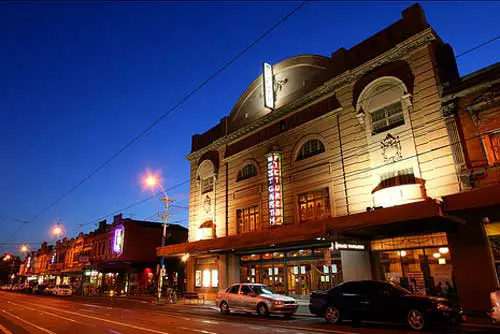
The Palace, Westgarth
WESTGARTH
Westgarth is a residential suburb where the tram and train services cross the Merri Creek, south of Northcote, 5 km. north-east of Melbourne. Land sales occurred in Northcote in 1840, but the land between Westgarth Street and the Merri Creek was withheld, probably as a reserve for a township in view of its proximity to water. In 1853 a township was gazetted, to be called Northcote. The cross streets, Cunningham, Urquhart and Walker, were named after three of the purchasers in the 1840 land sale. The northern-most Westgarth Street was named after William Westgarth (1815-89), merchant, politician and historian of colonial Victoria. Between 1845 and 1854 he owned land on the other side of Merri Creek. Northcote by the Merri Creek, however, did not attract settlementas quickly as the more elevated Ruckers Hill up High Street, which was the place to which the Northcote name migrated. Northcote-by-the-Merri became Northcote South.
The village, however, attracted some settlement, notably All Saints Anglican church (1860) and the Bridge Hotel (1864). The present church was built in 1870. To the west of the village the Jika Jika reserve was set aside, later to be Northcote Park and home for the Northcote Football Club. A railway line was opened in 1884 from Clifton Hill to Alphington, via Northcote South. Four years later it was linked to Melbourne, although by a circuitous westerly loop that terminated at Spencer Street. Two years later the High Street tramline opened, only to close twice before reopening permanently in 1901. During the period 1906-10 the railway station was named Westgarth, and the area took on that name. Being only a short way beyond Clifton Hill, and having rail and tram services, Westgarth was eminently suitable for residential settlement by the turn of the century. Its housing is mostly Victorian and Edwardian, with a smattering of California bungalows.