

A substantial rural service centre known as the 'Gateway to the Warrumbungles' - a beautiful range of mountains in the Central West - Coonabarbran a quiet and attractive country town of 2900 people on the Castlereagh River.

Where Is It?: Coonabarabran is 451 km north-west of Sydney between Gilgandra and Gunnedah and 509 m above sea-level.
The Coonabarabran Visitors' Centre is located on the Newell Highway, tel: (02) 6842 1441. They can furnish information about local farmstays, horse riding, scenic flights, guided tours and tourist drives and can sell you a Super Nova Ticket, allowing you to see both the Skywatch and Siding Spring Observatories at a discounted price. Tune to FM 88 for a radio broadcast of local information.
Events: Festival of the Stars, held every November, is a month-long event celebrating arts and astronomy in Coonabarabran. Highlights include concerts, exhibitions and "Science in the Pub", where scientists debate hot topics in astronomy over a cooling ale.
Things To see and Do
Australian Natural History Museum has displays relating to ancient Australian megafauna, it includes the most complete skeleton in Australia of a diprotodon, the largest known marsupial that has lived. Something like a buffalo-sized wombat, it roamed the area 34 000 years ago. There is also a small local history collection and a display relating to Dreamtime legends.

Pilliga Pottery consists of a mudbrick workshop and showrooms and a bush cafe serving Devonshire teas. They are open seven days a week, Ph (02) 6842 2239. Head north-east towards Narrabri on the Newell Highway and take the signposted left 23 km from Coonabarabran.
Siding Spring Observatory (24 km west) in the Warrumbungle Range, is Siding Spring Observatory, a complex of international importance which has the largest optical research telescope in Australia (3.9 m). It is a hands-on experience with an interactive exhibition, a theatrette, a science gift shop and cafeteria. They are open from 9.30 a.m. to 4.00 p.m daily and guided tours for groups can be arranged.
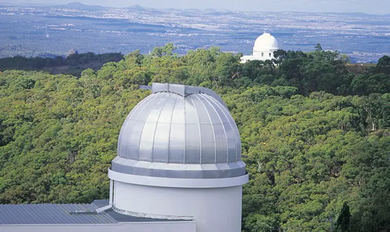
Skywatch Night & Day Observatory (2 km west): its attractions include hands-on usage of powerful telescopes as well as simulated computer games, a theatrette, a pictorial history of astronomy, a special planetarium, a gift shop, snacks and a mini-golf course with an astronomy theme. The observatory is open each day from 2.00 p.m. to 5.00 p.m. with night-sky viewing from sundown (astronomy session times vary seasonally).
Crystal Kingdom houses 'Minerals of the Warrumbungles' - a collection of the world's most colourful and rare zeolite crystals, found locally. There is a huge crystal cave, as well as local fossils and a gift shop which has jewellery, including set and unset gemstones. A guide is on hand to explain the geological history of the Warrumbungles and the development and qualities of the crystals.
Surrounding area

The Warrumbungles is the remnants of a large, heavily eroded shield volcano that was active from 18 to 15 million years ago. A huge shield-shaped volcano formed as volcanic explosions occurred over millions of years. The remaining complex, rocky formations are what is left after millions of years of erosion.
The range lies between the moist eastern coastal zone and the dryer plains to the west. Due to this position the mountains have provided protection for flora and fauna suited to both habitats. There are over 120 different bird species that have been identified on the range, including Lories and lorikeets, rosellas and parrots. In the centre of the range has served as an area of protection for a healthy and content colony of grey kangaroos. These animals have become fairly tame due to constant visitor attention and are easily approached.
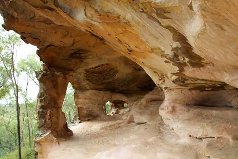
The Sandstone Caves in the Pilliga Nature Reserve were formed by the natural erosion of a soft sandstone area. Significant Aboriginal site for the local Gamilaraay people, they are a series of cathedral type caves exhibiting an array of rich colours, sizes and shapes. Walking around the caves you can feel the finely weathered sand under your feet. The caves are closed from September to November to allow for the safe breeding of an endangered bird species. Accessed via the Newell Highway. There is a small entry fee, Ph: (02) 6842 1441.
The reserve is just to the north of Coonabarabran and it encompasses around 80,000 hectares (3,000 square kilometres) of semi-arid bushland, also known as Pilliga scrub.

Hickey Falls are located at the end of a short walking track which departs from a roadside stop, 42 km south-west of Coonabarabran on the Oxley Highway, en route to Gilgandra. There is a pleasant waterhole for swimming in summer, as well as picnic and barbecue facilities.
Brief History: The town's name derives from the language of the Kamilaroi people who inhabited the area prior to white settlement, though its meaning is now highly uncertain.
The first European to discover the Castlereagh River was George Evans, a member of John Oxley's 1818 party which passed 25 km to the north during the expedition which led to the European discovery of the Liverpool Plains.
The 'Cooleburbaran' sheep run was established in 1836 and, in the late 1840s, became known as 'Coolabarabyan' when it was owned by James Weston who grew wheat and established a mill.
Attractions
Video Features

-
Regional Guides
- Sydney
- Blue Mountains
- Hawkesbury River
- Hunter Valley
- Central Coast
- Mid North Coast
- Northern Rivers
- North West Slopes
- New England
- Southern Agricultural
- South Coast
- Illawarra
- Southern Highlands
- Snowy Mountains
- Riverina
- Central West
- Far West
Travel in Australia
- About Australia
- Coming To Australia
- Getting Around
Search and Book
- Accommodation
- Flights
- Cruises
- Tours
- Ferries and Cruises
- Train Travel

