


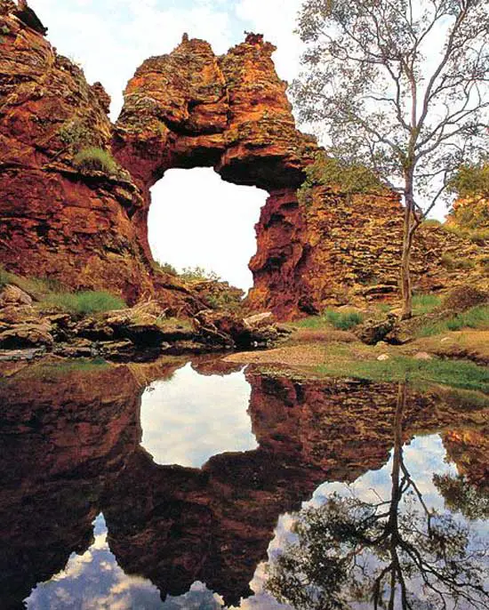
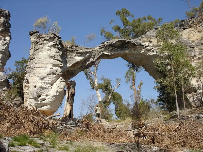
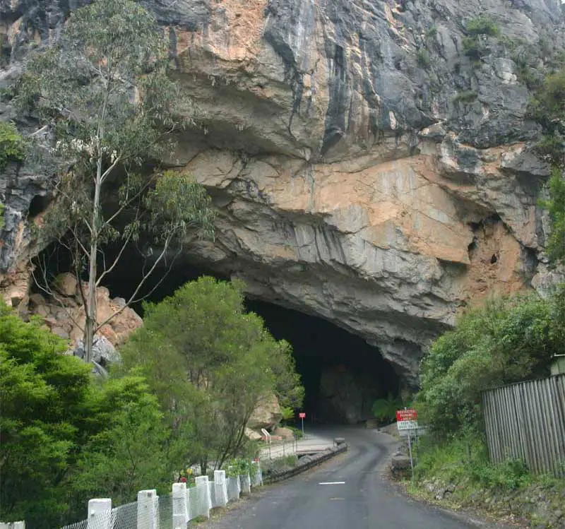
Located 157 km east of Mount Magnet and 661 km north of Perth in Western Australia’s East Murchison district, Sandstone is a town which started life as a boom goldrush town. Gold was first discovered in the immediate Sandstone area in 1894. From 1907 Sandstone grew to a small city of some 6,000 to 8,000 people but had become a virtual ghost town by the end of World War 1. Up the track from the State Battery is the town’s most interesting natural phenomenon – London Bridge. It is the most spectacular and unusual of the sandstone breakaways in the area and, in the early 1900s, was once wide enough to allow both horse and sulky to cross it. Over the years however, it has been eroded to its present width of one metre. It is now regarded as too dangerous to walk on. The sandstone in this area is estimated to be 350 million years old. The bridge itself is nearly 800 metres long and at the centre is 10 metres high.
- More
- More
- More
- More
- More
- More
- More
- More
- More
- More
- More
- More
- More
- More
- More
- More
- More
- More
- More

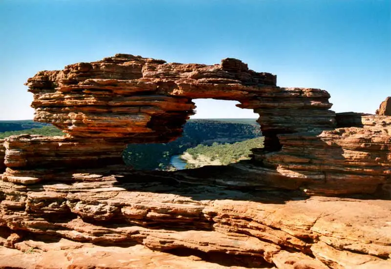
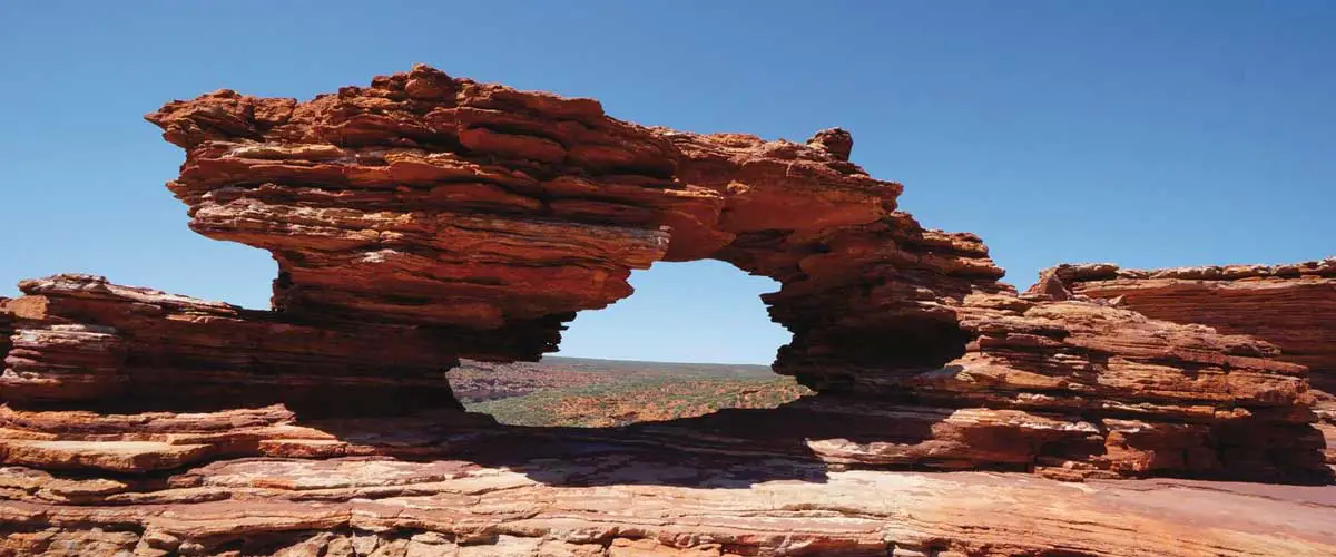
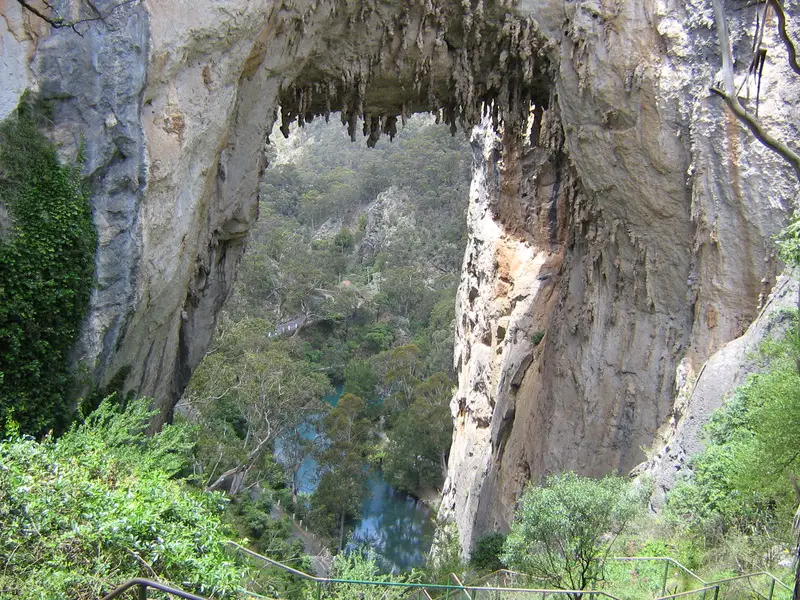
The river gorges in the Kalbarri National Park are some of the most accessible and spectacular in Western Australia. The gorges have been carved over millions of years to form dramatic sandstone cliff faces that plummet into the Murchison River as it meanders towards the township of Kalbarri on the coast. The rugged terrain and relative seclusion of the Murchison River gorges attracts thousands of visitors each year. Short walks provide moderately easy access to lookouts along the river gorge at the Loop, Z-Bend, Hawks Head and Ross Graham lookout. The Loop provides different views of the winding gorge below from several lookouts positioned around The Loop. One such vantage point is Nature’s Window, a natural rock arch that superbly frames the upstream view.
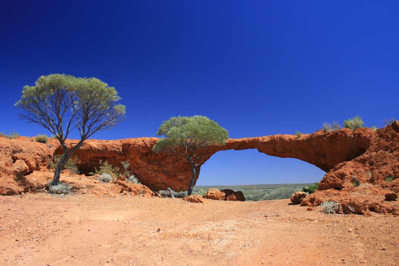
This natural arch is found on the Connie Sue Highway, which traverses the Great Victoria Desert. The route follow in the footsteps of explorers Frank Hann (1903-08), The Elder Expedition (1891) and Len Beadell. The highway was built by Beadell, a surveyor for the Australian Army, and his team in the late 1950’s and early 1960’s and was named after his wife daughter. Anne Beadell Highway was nsmed after his wife. Waterfall Gorge was named by Frank Hann in March 1906. The gorge covers a significant area. The most notable feature is without doubt the fragile looking natural stone arch, located on the eastern side of the gorge area.
Rainbow Bridge was discovered in 1998 by Richard D. Fisher in a remote section of the Bungle Bungle Range in Purnululu National Park in the Kimberley region of Western Australia in the state’s far north. It has an estimated span of 9 metres and height of 12 metres, and spans a small creek. The area is closed to visitation except by special research permit.
This arch is located in the Purnululu National Park (The Bungle Bungles) in The Kimberley area of Western Australia.
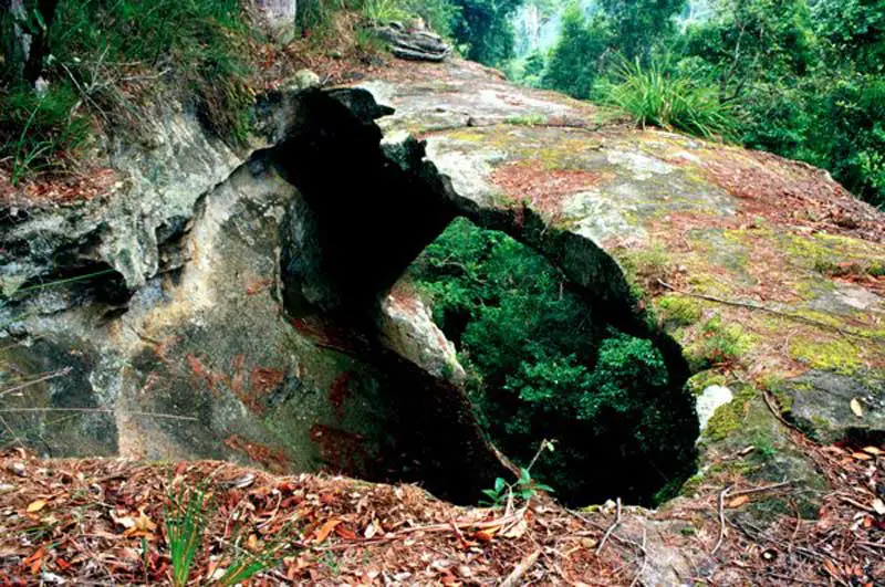
This small picturesque arch (not in photograph) is in Mirima National Park (Hidden Valley) near to the town of Kununurra in Western Australia. It has a span of 1.2 metres and a height of 2.2 metres.
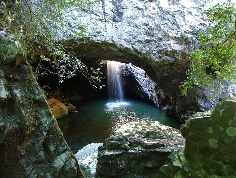
The Natural Bridge is an area located at the southern end of Numinbah Valley in Gold Coast hinterland. Here, the rainforest springs and short tributary creeks such as Cave Creek form the headwaters of the Nerang River. This ancient geological phenomenon associated with one of these creeks. Through the process of time a deep cave formed behind a waterfall on Cave Creek. Upstream of the falls, a pool was scoured by tumbling water and rocks until the waters partially broke through the basalt rock of the creek bed to flow into the large cave below . This diversion of the stream created a perfect arch or bridge in the rock above. At the formation, formation, a waterfall plunges through the roof of a cave into a beautiful sun-dappled rainforest grotto, which is home to glow-worms, bats and other denizens of the dark. The creek then continues on its course to join downstream with the Nerang River. It is documented that two timber-getters, Alexander (Sandy) Duncan and Din Guinea were the first Europeans to sight the Natural Bridge. They were cutting timber in the rain-forest just above what was then an unnamed stream. Sandy had reportedly gone down to the creek for water to boil the billy when he came upon the bridge and cave. From then on the local timber-getters and later settlers referred to the place as the Natural Bridge.
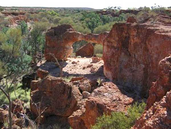
Situated 160km north west of the tiny central Queensland town of Injune, Mount Moffatt is home to some of the most bizarre and weathered formations found anywhere in Australia. Cathedral Rock, the Dutchess and the Chimneys are all located not far from the park entrance and can be easily accessed from the road along short, flat walking tracks. Another spectacular masterpiece in stone is Marlong Arch, which is located near the centre of the park. Erosion over countless millions of years has slowly eroded out a magnificent arch from a sandstone cliff, leaving only a thin sliver of sandstone to bridge it at the top. About six kilometres further on from this spot is Lot’s Wife, which is a rather breathtaking, vertical column of sandstone rising dramatically from the forest floor.
The main attraction of Undara National Park, a few hundred km southwest of Cairns, are its lava tubes. They are the largest, longest and most accessible lava tubes on earth. The Undara volcano erupted 190,000 years ago and spewed 23 cubic kilometres of molten lava onto the surrounding country. Streams of sulphurous lava flowed over the land, spilling out like boiling treacle into various creek beds and other depressions. The surface soon cooled and crusted but the molten lava inside continued to flow, leaving behind these huge hollow pipes. The large bridge at Undara was caused by the collapse of one of the tubes. It has a span of 20 metres and a height of 11 metres.
Chillagoe-Mungana Caves National Park, about 201 km west of Cairns, is an area of many caves. The Royal Arch Cave is located 7km south-west of Chillagoe while the Donna, Pompeii, Bauhinia and Trezkinn caves are located 1.5km from the centre of town. Another cave, The Archways, is at Mungana, 15km north-west of Chillagoe. As well as caves there are a number of interesting shaped rocks, such as The Balancing Rock, and numerous limestone arches. Many of these arches are in dark locations and are hard to photograph, unlike this arch at the leading edge of a rock face. It has a span of about 7.6 metres and a height of 5.8 metres.
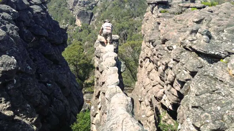
This arch is a narrow rock ledge situated near the Pinnacle in the Wonderland area of The Grampians National Park in Victoria. It is just off The Pinnacle trail just after passing The Pinnacle. The arch has a span of 11.6 metres and a height of 4 metres. The nerve test is to walk to the end of it.
Jenolan Caves is located approximately 181km west of Sydney and is a major tourist attraction. Development within the caves, which included pathways and the protection of formations, began, an accommodation house was constructed and in 1887 permanent electric lighting was installed. Wilson was to continue his exploration, discovering the Jersey Cave in 1891 and the glorious Jubilee Cave in 1893. The present day Caves House was constructed in 1898 after fire partially destroyed the original buildings. What is often missed on a visit to the caves is the huge rock arch called the Grand Arch that all vehicles must pass through on their way to the main carpark. The arch was once the entrace to a large limestone cavern now occupied by the carpark, Caves House and visitor facilities. Due to water seepage, the cave collapsed many centuries ago, but the arch remain. The Grand Arch is the largest open cave in Australia. It is 24 metres high, 55 metres wide and 127 metres long. Carlotta Arch, another large cave remnant, is like a window looking out high above the Devils Coach House.
Another large cave remnant at Jenolan Caves, Carlotta Arch is like a window looking out high above the Devils Coach House. The arch is one of the most photogenic natural arches in Australia. A hiking trail climbs up to and behind the arch, allowing photography from both sides. This trail then proceeds to and through The Devil’s Coach House. Carlotta Arch has a span of about 20 meters. A viewing platform under the arch offers views to Blue Lake. Whilst freestanding arches like this are not common, they are not entirely unexpected. A stream once flowed across this part of the landscape creating a cave. The surface of the rock has then been gradually worn away and as it has done so, the cave has gradually collapsed and the rock around it has disappeared. In time most of the cave vanishes leaving only a brief section of it. What is seen is therefore a cross-section from partway along the cave. With time this rock, too, will be worn away and when this happens the arch will finally collapse. Carlotta Arch is named after Carlotta Adams, daughter of P.F. Adams who surveyed the Devils Coachhouse in Easter 1878.
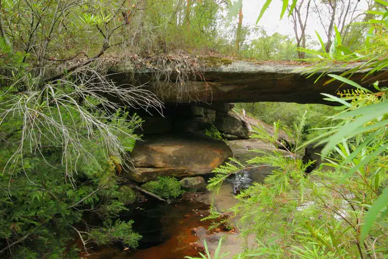
This natural bridge is located in Watagans National Park. The park protects the headwaters of the Congewai and Quorrobolong creeks, which drain into the Hunter River, and the Gap and Dora creeks, which drain into Lake Macquarie. The park affords spectacular views of rainforest gullies from the Monkey Face Lookout, sitting above the Martinsville Valley. Boarding House Dam picnic area, set among large blackbutt and blue gum trees, offers rainforest walks along the creek, or a paddle on a hot summer’s day. Red cedar and Illawarra flame trees line the walk to Gap Creek Falls from the picnic area. The Watagan Mountains are located west of Newcastle, close to the town of Cooranbong. This scenic area was state forest for many years.
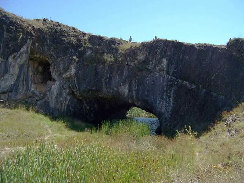
A natural limestone bridge to the south of Queanbeyan, it was formed when sediment and corals remains were deposited on an ocean floor 420 million years ago. It was then subjected to intense pressure. Over time the ocean receded and erosion shaped the landscape. The arch was formed by water slowly leaching through the limestone, enlarging cracks until a passage became big enough for Burra Creek to pass through. It reached its pesent size about 20,000 years ago. The arch was first recorded by Europeans in 1823 when explorer Capt. Mark Currie was directed to the arch by an Aboriginal guide. Currie described it as ‘anatural bridge of one perfect Saxon arch, under which the water passed’.
A natural sandstone bridge occurs in Garigal National Park, which encompasses much of the remaining stands of natural bushland on Sydney’s Upper North Shore, particularly those around Middle Harbour Creek and its tributaries. It can be found by accessing the Bay Track via the Cook Street Track, which has entry points in Cook Street and Currie Road, Forestville. This track takes bushwalkers past three small waterfalls on the Main Creek before reaching The Natural Bridge Track. As its name suggests, the track leads to a natural rock arch which spans Main Creek deep in the valley. The track continues up a steep hill to the Bluff Lookout which offers panoramic views south across Bantry Bay.
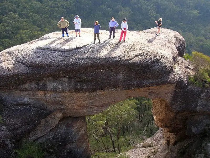
Only a short distance away from the South Coast of New South Wales is the Budawang Mountain Range, which is dominated by the Scenic Rim, a spectacular cliffline crowned by the mountainous formations of Pigeon House, Corang Peak and The Castle. This is magnificent mountain country, forming an awesome backdrop to the sparkling coast below. Rugged yet gentle, foreboding yet beckoning, the grandeur of these mountains is obvious from near or far. Corang Arch, an impressive bit of erosion, is much larger than photos indicate. Many more arches are forming in the cliffs of this large sandstone spur, but none will rival the height and size of Corang Arch. The Arch is found on the western side of the northernmost tip of Corang Plateau, not far from the descent on the conglomerate slope. It is easily found if walking close to the cliff edge. Access is through a small cave (forming another smaller arch) in the rock platform at the cliff edge. An easy scramble through the cave and down to the arch itself reveals a short easy climb onto the top of the arch or a short descent to a cave in the cliff between the arch and the plateau for excellent views through the hole to the valley below. The top of the arch afford views of the spectacular tall conglomerate cliffs and rainforests of the Budawangs, Byangee Walls and Pigeon House.
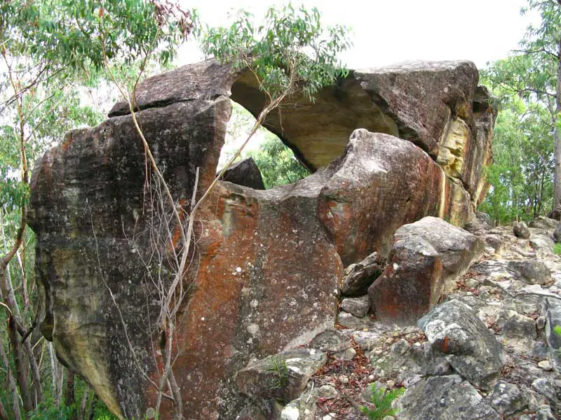
Hollow Rock, scuptured by wind and erosion centuries ago, is to be found in the Culoul Range deep in the heart of Colo Gorge in Wollemi National Park, North-West of Sydney, NSW. The gorge is surrounded in many places by impassable cliffs and walking along the river and side creeks is slow due to the boulders. The Colo Wilderness is rugged and remote and in places is the domain of only the more experienced bushwalker. The word “colo” is an aboriginal variant of “koala”. The explorer Francis Barralier mentions the word in his writings of 1802. He was attempting to find a way over the Blue Mountains at the time. The word “colo” is an aboriginal variant of “koala”.
The explorer Francis Barralier mentions the word in his writings of 1802. He was attempting to find a way over the Blue Mountains at the time. In the 1800’s a rough track was built along and, in places, above the Colo gorge. The plan was to survey a railway line which would cross the Blue Mountains. A railway survey was also conducted along the Grose River in 1857, resulting in the construction of the Engineer’s Track. The plan was never realised and the track is now barely discernable, being largely obscured by landslides and plant growth.
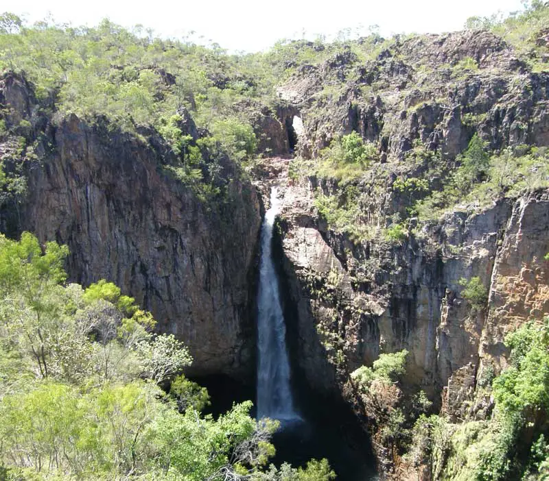
A walk to the upper reaches of the Tolmer Gorge in Litchfield National Park, NT, starts just before the lookout for Tolmer Falls. The walk meanders through the broken sandstone around the gorge rim and is a good example of how the flora in this area has adapted to the poor soils and the lack of water in these areas for most of the year. It passes close to a natural arch carved out of the rock through which the creek flows on its way to the top of the falls. A little further upstream the creek passes through a steep gully before dropping into and flowing through a deep circular cavern known as The Cauldren.
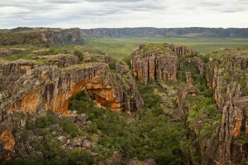
Known simply as The Archway, this natural arch near the border of Kakadu National Park dramatically illustrates the erosion that has carved out the many rock features of the Arnhem Land sandstone plateau. It is the largest of hundreds of arches and caverns scattered throughout this ancient countryside. Being on Arnhem Aboriginal tribal land, it is not accessible to the public by land. The only way to see is by taking a helicopter or airplane trip out of Jabiru Airport in Kakadu National Park. It is included on most aerial tours of the Park, which also take in Magela Falls, Dinosaur Valley, Mikinj Valley, East Alligator River, Magela Wetlands and the Jim Jim and Twin Falls. Kakadu National Park is a Commonwealth Reserve covering almost 20 000 square kilometres, and includes the traditional lands of a number of Aboriginal clan groups. Kakadu is managed jointly by its Aboriginal traditional owners and the Director of National Parks